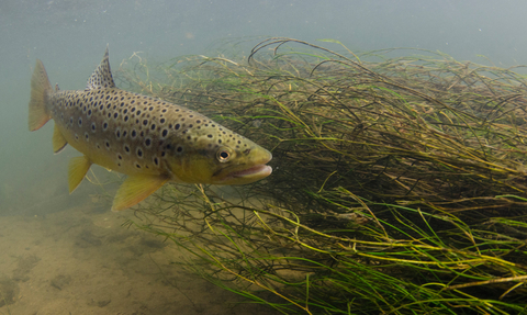
Brown trout by Jack Perks
River Catchment Partnerships
The Cherwell and Ray Catchment
The Cherwell and Ray Catchment encompasses the two ‘operational catchments’ of the River Cherwell and the River Ray (the Cherwell’s largest tributary). It comprises an area of 943km2 and crosses multiple county and local authority boundaries.
From its headwaters near the village of Charwelton in Northamptonshire, the River Cherwell flows southwards, passing through Banbury and Kidlington before flowing into the Thames at Christchurch Meadow, Oxford. The River Ray has its headwaters near Quainton in Buckinghamshire, from which it flows slowly south-west past Bicester to its confluence with the River Cherwell at Islip. Other than these key urban areas, the Cherwell catchment is very rural, with a high proportion of arable land.
Like many other lowland rivers in the country, the Cherwell and Ray suffer from pollution from farmland, sewage and domestic wastewater. They are also affected by invasive non-native species and over-development. The rivers are not as healthy as they could be: neither are classed as in “Good” ecological status.
However, these rivers are also home to rare invertebrate species such as the fine-lined pea mussel, and the banks and reedbeds host numerous bird species such as kingfishers, reed buntings and hobbies. Otters have returned to the Cherwell and are found throughout the catchment.
The Catchment Partnership was set up by BBOWT in 2014, as the catchment ‘host’ organisation. Thames21 joined to co-host in 2022.
Our partnership vision for the catchment
We aim to bring together all interested parties in the Cherwell and Ray Catchment to collaboratively protect, enhance and improve its water environment through a shared vision:
To ensure the catchment is clean, healthy and full of wildlife, that it is enjoyed, valued and managed sustainably by all for the long-term.


